Thursday, July 31, 2014

Satellite Map

http://blogs.worldbank.org/sustainablecities/george-washington-and-land-readjustment

Satellite image by Google Earth of Washington DC

Continuously Variable Proportional Circle Map


http://go.owu.edu/~jbkrygie/krygier_html/geog_353/geog_353_lo/geog_353_lo11.html


Graduated symbol maps
  • also called proportional point symbol mapping
  • variable point symbol mapping
  • ArcGIS: Graduated (classed) vs Proportional (unclassed) symbol maps

Unstandardized Chroleth map

http://www.ij-healthgeographics.com/content/3/1/18/figure/F6

Choropleth map of Bayesian smoothed prevalences in Lower Saxony. Choropleth map of the empirical Bayesian smoothed period prevalences from 43 regions in Lower Saxony. Cut points of the grey scale shading are the 5%, 50% and 95% quantiles of the empirical distribution.              

Bivariate Choropleth map

http://www.geo.unizh.ch/~annal/Choropleth%20maps.html

      The project focused on representing geographical relationship on choropleth maps. The results of the usability test, comparing effectiveness of bivariate and univariate maps, verify opinion about poor readability of two-variable choropleth maps. Two-variable maps can be properly understood by the readers and hence can serve as an effective tool for a visual exploration of geographical relationship.

Unclassed choropleth


http://go.owu.edu/~jbkrygie/krygier_html/geog_353/geog_353_lo/geog_353_lo07.html


"Unclassed" choropleth maps: the number of categories is equal to the number of data values
Each value has a unique symbol
    ex) range of values from 0 to 100 represented with 0% to 100% black

Political Map

http://www.worldatlas.com/aatlas/infopage/political.htm

Political maps are designed to show governmental boundaries of countries, states, and counties, the location of major cities, and they usually include significant bodies of water. Like the sample above, bright colors are often used to help the user find the borders

Equal Interval

http://www.virginiaplaces.org/regions/whatboun.html


Black and White Aerial photo

http://www.britainfromabove.org.uk/image/wpw032442

View of Brynmawr, oblique aerial view. 5”x4” black and white glass plate negative.

Parallel coordinate graph

http://www.intechopen.com/books/biosensors/symbolic-modelling-of-dynamic-human-motions


Parallel Coordinate Plot: providing visualisation of all selected features, for all participants (p1-p10) —covering here, 3837 data frames.

Accumulative Line graph

http://www.fhwa.dot.gov/publications/research/infrastructure/pavements/pccp/02086/chapt6.cfm


Lorenz curve

http://www.worldbank.org/depweb/english/beyond/global/chapter5.html


To measure income inequality in a country and compare this phenomenon among countries more accurately, economists use Lorenz curves and Gini indexes. A Lorenz curve plots the cumulative percentages of total income received against the cumulative percentages of recipients, starting with the poorest individual or household

Isopleth

http://www.stonelions.com/DuPont.htm


 isopleth map depicting 1992 annual average dioxin concentrations in the vicinity of the Dupont plan

Isopach

http://www.searchanddiscovery.com/documents/abstracts/2005hedberg_vail/abstracts/extended/yurewicz/images/fig02.htm

Isopach of the "gas column" (based on continuous gas shows) above the Rollins Sandstone

Isohyet

http://pubs.usgs.gov/of/1999/ofr-99-0518/ofr-99-0518.html


Isohyets for total rainfall from Hurricane Camille, August 19 and 20, 1969 in Nelson County, Virginia. Rainfall measurements plotted are in inches and are taken from Camp and Miller (1970). Plus signs indicate that rain gauges overflowed and only minimum rainfall is known.

Isotach

http://severewarningsystems.com/pre_storm_prep.html

THE 500 MB ISOTACH

Isobar


https://www.ametsoc.org/amsedu/dstreme/extras/usr_guide/Pressure.html

Isobars (map on right) are blue lines which connect equal pressure values based on the set from 1000 mb with an interval of 4 mb above or below that. Isobar values are labeled in blue within the isobar lines that are contained in the map area. Additionally, centers of locally highest and lowest pressures are marked by a blue H and red L, respectively.

Infrared Aerial

http://www.camdencountylandtrust.org/Grover%20Island.htm

COLOR INFRARED AERIAL PHOTOGRAPH OF GROVER ISLAND, NORTH AT TOP. (Island is about 1.4 miles across, east-west.)

Doppler radar

http://www.srh.noaa.gov/tae/?n=climate_2005review


Doppler radar image of Hurricane Dennis as it made landfall between Navarre and Gulf Breeze, FL, on the afternoon of July 10, 2005.

Scatter plots

http://www.nature.com/nprot/journal/v7/n3/fig_tab/nprot.2012.005_F6.html


Scatter plot of cluster expression between two biological replicates

Climograph

http://www.uleth.ca/vft/waterton2/Climate.htm


A climograph created from temperature and precipitation measurements at Waterton Park Gate (Environment Canada, 2005). A monthly average of the data from 1996-2004 was used to create the graph in Excel.

Triangular plot

http://faculty.njcu.edu/wmontgomery/Coastal_Zone/Grain%20Size%20Distribution.htm


Another widely used classification system is the soil triangle of basic soil textural classes. This naming system is commonly used by the U.S. Department of Agriculture and the U.S. Soil Conservation Service. In this system the relative percentages of three particle size catagories are considered. The three catagories of particles are sand, silt, and clay. The triangular diagram is subdivided into several soil textural classification types, with each soil type comprising a range of percentages of the three particle types. The soil classification type is determined by plotting the percentages of each of the three soil particle classes found within the soil sample on the triangular diagram. The point of intersection of each of these three particle class percentages will fall within one of the soil classification types (see Soil Classification Triangle).
As can be seen by inspection of the triangle, each of the three particle types can vary from zero to 100% of the content of a sediment sample. For example, a 100% clay textural composition would plot at the apex at the top of the triangle. Lesser percentages of clay content would plot somewhere between the top apex and the base of the triangle. The same technique holds true for sand or silt content except that the 100% sand or silt content points are located at the left and right bottom apexes of the triangle respectively. Lesser contents of sand or silt would plot somewhere between the 100% apex and the side of the triangle opposite that apex.


DEM

http://www.usgs.gov/features/lewisandclark/Mapping.html

This is an example of graphical elevation data for the St. Louis, Missouri area. Elevation data are an essential part of many Earth science applications. They are used for such diverse purposes as providing shaded-relief backgrounds, stratification in land cover classification, geometric and radiometric correction of remotely-sensed data, landform characteristics such as slope and aspect, and for geographic information system analysis of synthetic drainage networks and watershed delineations.

Digital Line Graph

http://geochange.er.usgs.gov/sw/resources/sw_basemap/

General Map of the Southwestern United States

digital Raster Graphics

http://www.tceq.state.tx.us/gis/drg.html

Digital Raster Graphics (DRGs) are scanned images of U.S. Geological Survey (USGS) topographic maps. The scanned image includes all standard map collar information. The image inside the map neatline is georeferenced to the surface of the earth, making it possible to use DRG as a map layer or theme in many GIS software packages.

DOQQ

http://www.utexas.edu/depts/grg/hudson/grg360g/EGIS/final_project/spring04_projects/web_justin_reynolds/Lake%20Travis.htm

Project Description:
Since the completion of Mansfield Dam (then the Marshall Ford Dam) in1941, the 100 year floodplain for Lake Travis has been recognized as 716 feet asl. However, a recent Corps of Engineer study in 2003 revealed that an elevation of 722 feet asl would be more accurate. The goal of this project was to create a new 100 year floodplain map for Lake Travis. Not only will this data be important for predicting floods, but changing the elevation of the floodplain means that hundreds of people that were outside the "danger zone" will now be within and will be required to purchase flood insurance under the National Flood Insurance Reform Act of 1994 if they have not done so already.

Statistical maps

http://www.policemisconduct.net/npmsrp-2009-preliminary-police-misconduct-statistical-report/


NATIONAL STATISTICAL MAPS

The following statistics only count state, city, and county law enforcement agencies since current federal law enforcement employment rates were not available for calculation. The statistical rates are based on the NPMSRP statistics and employment data provided by the 2008 US DOJ/FBI UCR.

Isoline

http://www.patheos.com/blogs/unequallyyoked/2014/01/7-quick-takes-11014.html

isolines tracing out travel times to different parts of the U.S. from NYC.

Cartographic animation

http://www.radicalcartography.net

Windrose


http://www.enviroware.com/windrose-pro-for-airports-runway-design/

Population profile

http://papp.iussp.org/sessions/papp101_s03/PAPP101_s03_060_040.html

Projected population structure for Botswana, 2020, with and without the impact of AIDS. The population pyramid depicted above shows the impact of an extremely high HIV prevalence, combined with a lack of anti-retroviral therapies, on the age structure of a population. This is often referred to as “population chimney”, as high mortality from AIDS in young adulthood leads to the distinctive narrowing in the upper half of the population pyramid. There is also a narrowing at the base of the pyramid due to the lowering of fertility because of the epidemic (through increased infertility and less women reaching motherhood) and due to increased infant mortality due to mother-child transmission of HIV.

Index value plot

http://econbrowser.com/recession-index

Shaded areas in the above figure denote the dates of NBER recessions, which were not used in any way in constructing the index. Note moreover that this series is entirely real-time in construction– the value for any date is always based solely on information as it was reported in the advance GDP estimates available one quarter after the indicated date, and the series by definition is never revised.

Correlation Matrix

https://www.bgc-jena.mpg.de/bgc-mdi/index.php/Gallery/Gallery?pic=25

Graphical representation of the correlation matrix of 13 highly correlated parameters. In the lower left triangle density estimates of the marginal bivariate distributions are shown (estimated with KDE). In the upper right triangle the linear correlation coefficients are shown. On the diagonal the univariate marginal distributions are shown. Compare also with previous picture.

Stem and leaf

http://www.teacherspayteachers.com/Product/Math-Data-Measurement-Stem-Leaf-Plot-Graph-Chart-PowerPoint-Common-Core-461992

Histogram

http://support.sas.com/kb/35/171.html

This sample uses the Graph Template Language (GTL) to produce a distribution plot. It uses a two-row lattice layout. The upper cell contains a histogram with normal and kernel density curves, a legend, and a table. The lower cell contains a horizontal box plot and a band plot.

Tuesday, July 29, 2014

LIDAR map

http://gallery.usgs.gov/photos/09_01_2012_rVMy5DCp53_09_01_2012_0

A 3-D terrestrial lidar scan of the Interstate-510 bridge in New Orleans taken Friday (Aug. 31, 2012). The U.S. Geological Survey is using this new technology in select areas of Louisiana, Mississippi and Alabama to map flooding in urban areas impacted by Hurricane Isaac.

Star plots

http://www.itl.nist.gov/div898/handbook/eda/section3/starplot.htm


The star plot consists of a sequence of equi-angular spokes, called radii, with each spoke representing one of the variables. The data length of a spoke is proportional to the magnitude of the variable for the data point relative to the maximum magnitude of the variable across all data points. A line is drawn connecting the data values for each spoke. This gives the plot a star-like appearance and the origin of the name of this plot.

Box plot

http://support.sas.com/sassamples/graphgallery/PROC_SGRENDER.html

Box plot map by group.

Cartogram

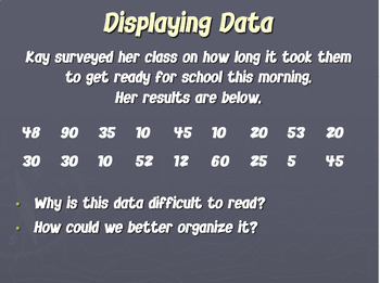
http://politicalmaps.org/2004-presidential-election-maps/

The cartogram was made using the diffusion method of Gastner and Newman. Population data was taken from the 2000 US Census.
The cartogram reveals what we know already from the news: that the country was actually very evenly divided by the vote, rather than being dominated by one side or the other.
The presidential election is not decided on the basis of the number of people who vote each way, however, but on the basis of the electoral college. Each state contributes a certain number of electors to the electoral college, who vote according to the majority in their state. The candidate receiving a majority of the votes in the electoral college wins the election. The electoral votes are apportioned roughly according to states’ populations, as measured by the census, but with a small but deliberate bias in favor of smaller states.
We can represent the effects of the electoral college by scaling the sizes of states to be proportional to their number of electoral votes, which gives a map that looks like this:

Flow map

http://www.viewsoftheworld.net/?p=716

Immigration to and from the United Kingdom.

Choropleth Map

http://www-nrd.nhtsa.dot.gov/departments/nrd-30/ncsa/STSI/12_FL/2010/12_FL_2010.htm


Fatality rates in Florida for 2010 per 100,000 by county population.

Dot Distribution map

http://www.fhwa.dot.gov/policy/2010cpr/chap2.htm

The distribution of rural and urban unlinked passenger trips across the United States.

Propoganda maps

http://www.bl.uk/collection-items/propaganda-map-war-national-industry-prussia

This map was used for propaganda, to appease the French people who were upset after the mutinies of summer 1917. It was meant to justify a lingering war that claimed many lives. It denounces the ambitions of the enemy, pointing out the historical power of Prussia over German land since the early 18th century. The reference in the top left-hand corner to Mirabeau, an 18th-century French revolutionary, writer and diplomat, introduces this historical aspect. Mentioning the declarations of a pan-Germanist association gives a contemporary twist to the Prussian threat. The purpose of this map was to give the impression on the French side that this war was a fight for freedom against Prussian ambitions, that it would liberate the French territories ‘seized’ by the treaty of 1871, which gave Alsace-Moselle to the Germans. The image of the octopus, popular at the time in this kind of document, suggests a threatening power that spreads its tentacles all over Europe.

Hypsometric Map


http://www.scilands.de/e_index.htm?page=/e_service/e_downloads/e_shaded_maps/shaded_maps.htm


Map of Spain, Portugal, and Andorra showing relief as a double shaded hypsometric map

Sunday, July 27, 2014

PLSS Map


This above is a combination map, representing both Civil Townships (colored areas), and PLSS Townships and Ranges (squares outlined in red).It was obtained from the Iowa Genweb site.

Cadastral Map


Lithuania: Extract from the digital cadastral map in urban area.

Thematic Map


Age 65 Plus Thematic Census Maps

Summary: Thematic map showing percentage of households with someone age 65+ for each county in the United States using year 2000 census data.

Topographic Map

http://www.virginiaplaces.org/geology/topo.html


Topographic map of Virginia showing mountain ranges and water. 

Planimetric Map


Cultural landscape report of the Fort Vancouver Barracks. 

Mental Maps


http://www.fedstats.gov/kids/mapstats/concepts_mentalmaps.html

 A mental map can best be explained as a visual display, inside a person's head, showing where a person has traveled. A mental map shows what the person knows about the location and the uniqueness of a place. No mental map is alike. Every human has his or her own mental map. This is a map from a Federal government website for kids.

Bilateral Graph

 
http://kff.org/global-health-policy/fact-sheet/the-global-hivaids-epidemic/


This bilateral graph shows the global funding to HIV/AIDS. The information was accessed from the Kaiser Family Foundation.